Welcome to Weed
We welcome you and your interest in our community. We are a growing city providing a safe and pleasing place to live, work, shop and play. A range of cultures comprise the Weed residential community, creating a pleasant and enjoyable social diversity.
The City of Weed has a solid reputation for being a team player for the good of the community. This has been demonstrated in our ability to obtain resources to enhance existing businesses, attract new businesses and improve our housing opportunities.
Partnership with the College of the Siskiyous has provided educational opportunities that also benefit our citizens.
The city staff is available to assist you. Careful attention is given to all– visitors, residents, single proprietor businesses, as well as major employers. We are here to answer questions and help with various processes. We welcome with open arms the visitors, new residents and businesses that wish to join us.
Our vision statement says, in part, that Weed is “…a friendly town where visitors are always welcome to share the beauty, culture and creativity this community nurtures and supports.” We take this statement seriously, and so can you. Welcome to Weed! us why we should make a purchase. Tap into your creativity. You’ve got this.
About Weed
-
Location
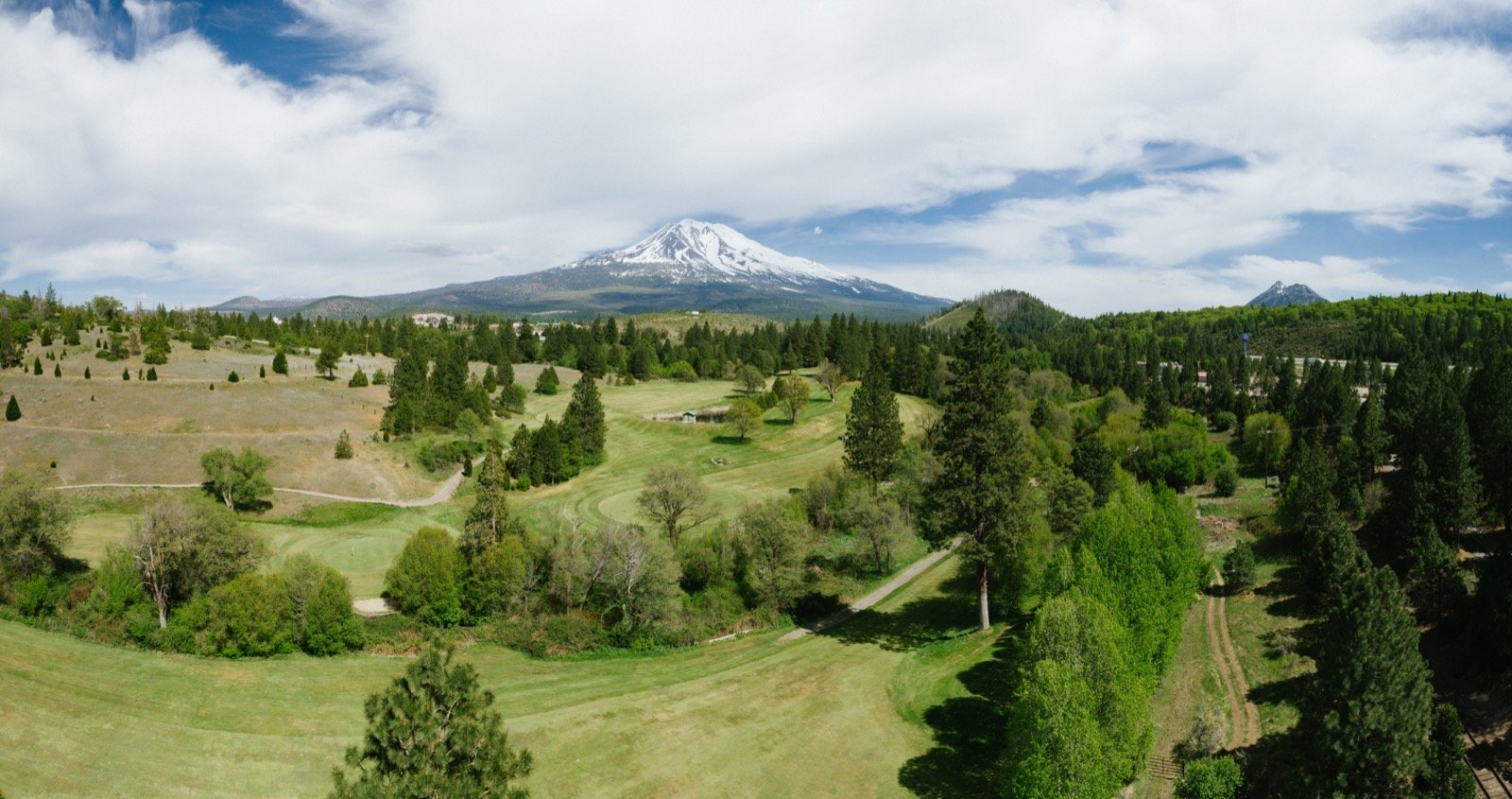
Weed is a small city midway between Portland, Oregon and San Francisco, and between Los Angeles and Seattle, Washington, on the I-5 corridor running north/south in California.
Weed is officially recognized as part of the Volcanic Scenic Byway, a 500 mile route beginning in California’s Lake Amador basin and ending at Crater Lake in Oregon.
The route traverses extraordinary scenery and geologic phenomena and links the four notable volcanoes in this part of the continent.
-
Climate
Four distinct seasons delineate the year in Weed. Summer’s heat is partially alleviated by the prevailing south winds. Average daytime temperatures range between 80 and 90 degrees, and there are periodic thunderstorms. Nights often cool into the 50s. Autumn weather can set in as early as Labor Day, and the winters are dry but sometimes snowy. Daytime winter temperatures average in the 30s to 40s, dropping to the mid 20s at night.
Springtime is often short, the last frost sometimes coming as late as Memorial Day. Weed’s elevation is 3,500 feet, and its growing season averages 100 days. The city is listed as a USDA Zone 6, and as Zone 1 in Sunset Magazine.
-
Population
Siskiyou County covers 6,287 square miles of forest, high desert, and mountain terrain. Although clustered for the most part in small cities and towns throughout the area, the 44,300 Siskiyou County residents have plenty of elbow room. Approximately 3,300 people live in Weed, with an estimated 7,000 more people living in the surrounding unincorporated area.
The city is home to people from diverse ethnic heritages living, working, schooling or retiring in a warm, small town culture in natural striking beauty and spaciousness.
Temperature
| Period | Avg. High °F | Avg. Low °F | Avg. Precip. |
|---|---|---|---|
| January | 42 | 23 | 7.06 in |
| April | 55 | 31 | 2.65 in |
| July | 84 | 47 | 0.39 in |
| October | 62 | 35 | 2.21 in |
Real Estate
-
Housing Resources
Siskiyou County Board of Realtors, Inc
(530) 926-5083Habitat for Humanity
(530) 938-2595Great Northern Co. (housing assistance) (530) 938-4115
-
Publications
Mt. Shasta Property Guide
(530) 859-0295
Published monthlywww.MtShastaPropertyGuide.com
-
Related Links
Local Chamber of Commerces
Mt. Shasta City
https://mtshastachamber.com/
McCloud
https://www.mccloudchamber.com/
Dunsmuir
https://dunsmuir.com/
Scott Valley
https://www.scottvalley.org/
Elected Officials
Siskiyou County
https://www.co.siskiyou.ca.us/
District Attorney (530) 842-8125
County Administrator (530) 842-8005
County Assessor (530) 842-8036
County Clerk (530) 842-8084
County Auditor (530) 842-8060
County Tax Collector (530) 842-8340
County Sheriff Administration (530) 841-2911
Superintendent of Schools (530) 842-8400
Weed City Council
550 Main Street
P.O. Box 470, Weed, CA 96094
(530) 938-5020
www.ci.weed.ca.us/mayorandcouncil
City Administrator (530) 938-5020
City Clerk (530) 938-5020
City Finance Director (530) 938-5020
Chief of Police (530) 938-5000
Fire Chief (530) 938-5030
Director of Public Works (530) 938-5020
Federal and State
Education
Public Schools
Administration
Siskiyou County Office of Education
609 South Gold Street, Yreka, CA 96094
(530) 842-5751
Siskiyou Union High School District
624 Everitt Memorial Hwy, Mt. Shasta, CA 96067
(530) 926-3006
Daycare / Preschool
Ana’s House
531 S. Weed Blvd, Weed, CA 96094
(530) 938-2604
Siskiyou Child Care Council
170 Boles Street, Weed, CA 96094
(530) 938-2748
Community College
College of the Siskiyous
800 College Ave., Weed, CA 96094
(530) 938-5555
Elementary / Middle
Weed Elementary School
575 White Ave, Weed, CA 96094
(530) 938-2715
Butteville Elementary School
24512 Edgewood Road, Weed, CA 96094
(530) 938-2255
High School
Weed High School
909 Hillside Drive, Weed, CA 96094
(530) 938-4774
Academic Programs
One of the smallest community colleges in California, all academic credits are fully transferrable per articulation agreements with accredited four-year schools. All core programs offer the sequence of classes necessary to fulfill transfer requirements. The COS academic curriculum also provides community residents educational opportunities for job enhancement and personal enrichment.
Library
Community residents as well as students may become COS library cardholders and benefit from the library resources on campus and online. The library itself contains approximately 35,000 volumes, and several banks of computers are available for student use. The extensive online material includes over 3,000 books and articles from thousands of newspapers, magazines and journals.
The COS library is also home to the “Mount Shasta Collection,” by far the largest collection of information and documents about Mount Shasta in existence. This body of work covers all current and historic aspects of the mountain, from its geological history to its legendary spiritual significance. Researchers from all over the world utilize this collection when studying Mt. Shasta.
Technological Resources
COS keeps pace with computer industry innovation. The computer labs devoted to writing and computer skills are upgraded to support the software students want and need for building skills competitive in today’s market.
Perhaps the most stunning example of this commitment is the Distance Learning Center, in operation since July 2003. Classes held in this center can be linked with classrooms in four other Siskiyou County towns. Participation by the students in each location occurs in “real time”: microphones, speakers and cameras in each classroom allow students to hear, see and interact with the teacher and each other.
The Distance Learning Center allows instructors to project lessons onto a classroom screen using TV, DVD, VCR, dedicated PC and document camera technology. Instructors can save all the work generated at the console onto a website accessible to students for use as review or to make up missed work.
Community Career and Technical Education
College of the Siskiyous honors a long-standing partnership with Weed and Siskiyou County agencies and businesses aimed toward sustaining a healthy local economy with technical programs.
Contract education is available for businesses introducing new technologies into their operations. Classes specific to the technology are offered at the college and open to public enrollment, in which the business’ employees receive the new training for a low per unit cost. A second option with customized training exclusively for employees can be held on campus or at the job site.
Business effectiveness training is now available through the college website, in a series of ten classes. Courses, training and services are available for prospective small business owners through partnership with the Jefferson Economic Development Institute (JEDI). COS is a resource for businesses relocating to the area through its partnership with Siskiyou County Economic Development Council (SCEDC).
Other partnerships allow COS to offer its nursing students practical support and work study opportunities during Certified Nurses Assistant (CNA), Licensed Vocational Nurse (LVN) and Registered Nurse (RN) training. Support is available through the Workforce Connection, taking the form of financial help, counseling, childcare or subsidies for uniforms and supplies.
Mercy Medical Center offers nursing students a work study job “shadowing” a member of the professional healthcare staff at its facility. Graduates of the LVN program at COS are guaranteed space in an RN program through Shasta College in Redding, about 60 miles south of Weed.
The Fire/Emergency Response program at COS is accredited by the CA State Board of Fire Services, so the college and test and issue certificates to newly trained firefighters. The Weed Fire Chief serves as fire technology coordinator, and provides access to his department’s equipment and facilities for training purposes. The California Department of Forestry also provides access to fire engines and other equipment.
The guiding principle for these partnerships is commitment to community from both an educational and a business standpoint. The local education and training of local people for local businesses and jobs allows everyone a share in the health of the community.
Medical Services
Hospitals
Siskiyou County has two medical centers, with a combined total of more than 75 physicians and surgeons and hundreds of other skilled professionals and support staff to serve most of the medical needs of its residents.
Mercy Medical Center Mt. Shasta, a designated Critical Access Hospital, is just minutes away from Weed and offers sophisticated compassionate health care services. Recognized as a national leader in providing “five star” health care, it is dedicated to delivering “world class service.” Twenty five acute-care beds include a labor/delivery/recovery unit, a medical /surgical unit, an ICU. A long term skilled nursing unit accounts for approximately another 30 beds. Mercy is a level III trauma center and a heliport for emergency transport by air ambulance. A new expanded surgical department is nearing completion.
Mercy Mt. Shasta is also the home of the Mercy Regional Cancer Center, sparing patients long distance travel to obtain radiation and chemotherapy. Its wide range of services include state of the art pharmacy, diagnostic laboratory and pathology, blood bank, cardiopulmonary services, physical/occupational and speech therapy — with branches in Weed and Lake Shastina, and hospice care. Radiology/oncology services include MRI, 16-slice CT, mammography/ CAD, nuclear medicine, linear accelerator for cancer treatment, bone density testing and ultrasound. One of most sophisticated and state of the art orthopedics programs in northern California is located there, run by specialists in hip, back, neck, shoulder and knee surgery.
Fairchild Medical Center in Yreka is an acute care facility also within easy driving distance from Weed. It is a Solucient “Top 100” hospital providing high quality, affordable and cost effective care. Patients will find a full range of in- and outpatient services available here, including medical, surgical, obstetric, diagnostic laboratory, pathology and physical therapy services.
Fairchild’s radiology department boasts new digital mammography/ CAD (Computer Aided Detection) and 3-D ultrasound systems as part of the facility’s dedication to early detection of breast cancer and general excellence in women’s health. Live 3-D ultrasound is the latest in the technology and is also used to examine unborn babies.
Both centers have 24-hour emergency rooms.
Other Health Care Facilities
Shasta View Nursing Center is a conveniently located long term care facility near the city center in Weed.
The county also supports six other outpatient physical therapy facilities, several home health care agencies, five assisted living facilities, various community clinics, and agencies serving developmentally disabled clients. Yreka also has a medical supply business for convenient purchase of many items needed by aging, disabled and post surgical patients.
Individual Providers
Individual practitioners throughout the county offer a broad spectrum of services:
Cardiology
Family practice
OB/GYN
Internal medicine
Dentistry
Ophthalmology/optometry
Mental health
Chiropractic
Podiatry
Physical/occupational and speech therapy
Orthopedics (with subspecialities in hip, knee, shoulder, back and neck), sports medicine
Nutrition
Obesity treatment
Vascular surgery
General surgery
Thoracic surgery
Home health care
Dermatology
Naturopathy
Chronic pain management
Pediatrics
Urology
Prosthetics
Ear, Nose and Throat
Respiratory therapy
Alternative practitioners, such as acupuncture, massage therapy, etc.
Medical equipment supply
Related Businesses
Personal Services & Care Directory
Medical Services
Doctors
Dentists
Health and Wellness
Hospitals
Mount Shasta Trail Association
Our mission is to provide inspiring outdoor experiences, advance appreciation of the beauty of the Mt. Shasta area, and assist in educating the public in environmentally sound stewardship by designing, constructing, maintaining and using trails in the Mt. Shasta area.